
Introduction
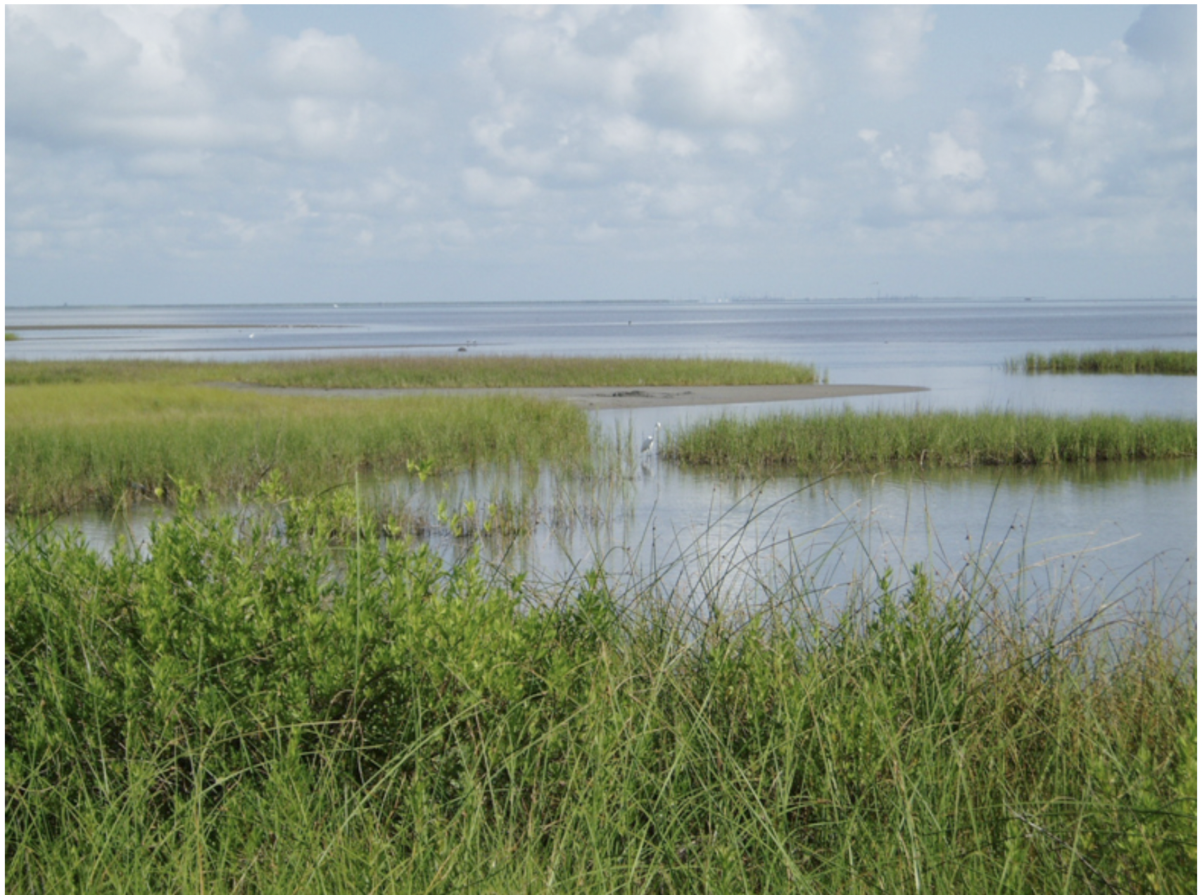
Figure 1
Source Bureau of Economic Geology, The University of Texas.
The marshes, bays, and estuaries of the upper Texas Gulf Coast form a complex matrix of rich biodiversity and massive biological productivity (Figure 1). As a result, the coastal wetlands are home to a large maritime food industry and to a popular sportfishing enterprise. The extensive biodiversity has made the area a world-class destination for avid birders, as well as those who simply wish to experience its natural beauty up close. As robust as they are in function and form, these coastal wetlands are also quite fragile and susceptible to harm from many natural and manmade disasters.
The blowout of the Macondo well on April 20, 2010, and the sinking of the Deepwater Horizon drilling rig threatened all Gulf Coast marshes, especially those in Louisiana. The subsequent release of more than 4 million barrels of oil promised a real disaster to the marsh areas of Louisiana and Mississippi that was partially realized before the well was finally capped. What are the chances that a similar incident somewhere in the Gulf of Mexico would bring destruction to the marsh and estuarial areas of the upper Texas Gulf Coast? To begin to answer this question, it is important to examine the complex movement of the water currents of the Gulf of Mexico and to consider how they might transport an oil spill in a given part of the Gulf to the marshlands of the upper Texas coast.
General Description of the Gulf of Mexico and Its Currents
The Gulf of Mexico is a Mediterranean-type cul-de-sac bordered by the United States to the north (Florida, Alabama, Mississippi, Louisiana, Texas), five Mexican states to the west, and the island of Cuba to the southeast.
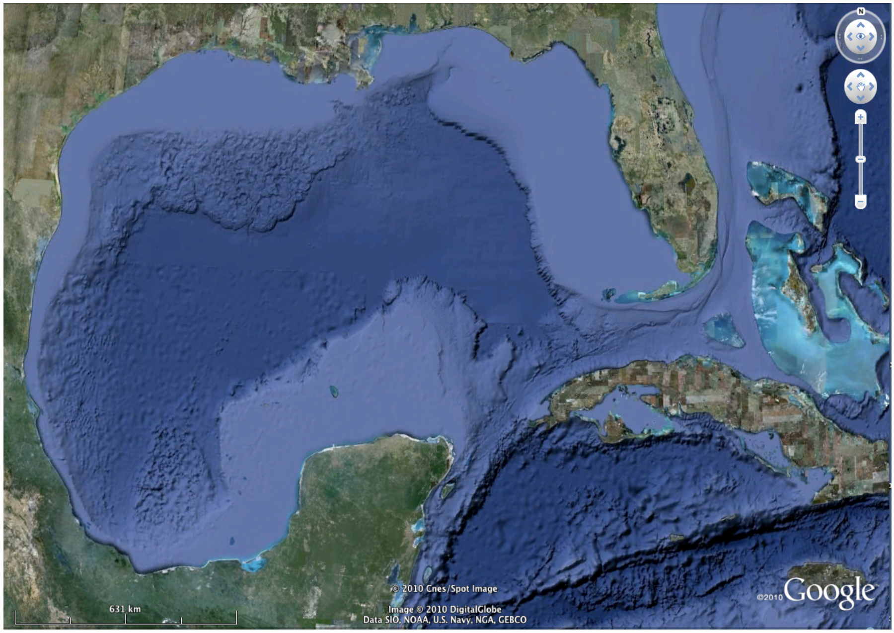
Figure 2
Source © 2010 Google.
The Gulf Basin resembles a large pit with a broad shallow rim. It has a surface area of 1.5 million square kilometers (sq km). Shallow and intertidal areas less than 20 meters (m) deep comprise approximately 38 percent of the Gulf. The area of the continental shelves (<180 m deep) represents 22 percent, and the continental slopes (180-3,000 m deep) represent 20 percent of the total Gulf area. The abyssal areas deeper than 3,000 m comprise the final 20 percent. The Sigsbee Deep, located in the southwestern quadrant, is the deepest region of the Gulf of Mexico and reaches depths greater than 4,000 m (Figure 2).
Water currents in the deep Gulf that extend up to the continental shelf are geostrophic (current governed by a balance between pressure gradients and Coriolis forces) and thus slowly circulate in a clockwise or anticyclonic direction. Water enters the deep waters of the Gulf through the Yucatan Strait, circulates as the “Loop Current,” and exits through the Florida Strait, eventually forming the Gulf Stream. The Loop Current is very swift (as fast as 5 miles per hour) and dominates the deep-water movement in the eastern Gulf. Portions of the Loop Current often break away, forming eddies or “gyres,” which dominate regional current patterns in the western deep water of the Gulf.
Surface currents along the continental shelf are wind-driven and tidal near shore. For the majority of the year, the winds are primarily out of the southeast. Thus surface currents off the western coast of Florida from Apalachee Bay to the Straits of Florida—and including the Florida Keys and Dry Tortugas—move primarily out from the coast or slightly up coast, with a bottom countercurrent returning back to the coast. The coastal currents from Tampa Bay to the Mississippi Delta are primarily driven to the west but return as bottom currents from along the shelf break to complete the circulation.
The Campeche Shelf of Mexico spans from the Campeche Bank, located north of the Yucatan Peninsula, across the Bay of Campeche to its west, to just east of Veracruz. The Eastern Mexico Continental Shelf is between Veracruz past the Rio Grande to the Laguna Madre in Texas. The Mexican shelf surface currents move generally to the west along the Mexican coast.
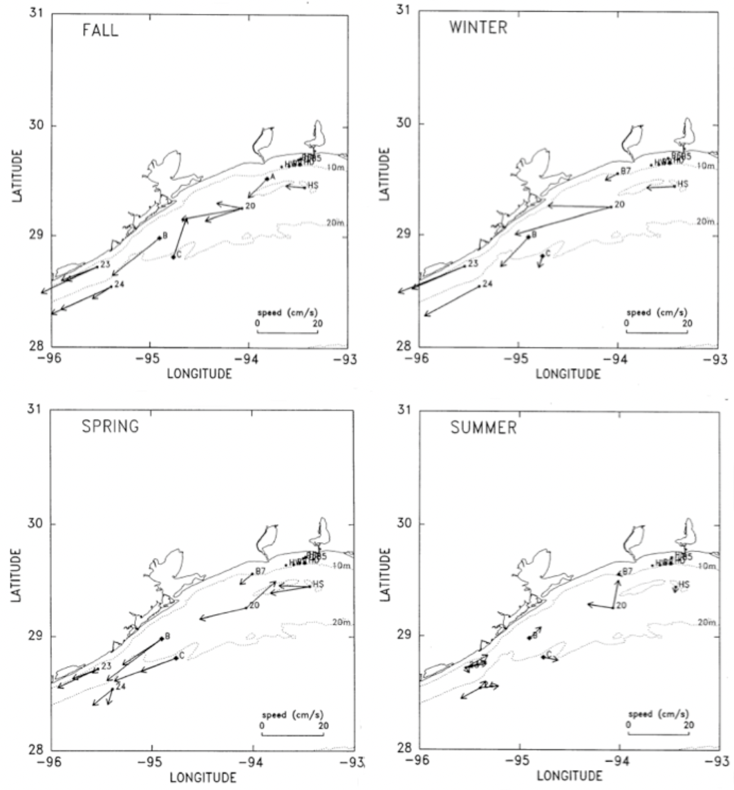
Figure 3
Source U.S. Department of the Interior, Bureau of Ocean Energy Management, Regulation, and Enforcement [BOEMRE].
The upper Texas coastal shelf lies along the western Louisiana and upper Texas coast (LATEX), stretching from the Mississippi River to Laguna Madre. The near-shore currents run parallel to the coast from north to south except in the hot summer months, when the wind and thus the surface currents are variable and unpredictable. Near the shelf edge, the currents move to the north, completing a counter-clockwise gyre (Figure 3).
The LATEX coastal current averages approximately 0.6 Sverdrups (Sv, where 1 Sv = 1 million cubic meters of water per second). About one-sixth of this flow consists of most of the outflow of the Mississippi and the Atchafalaya River systems, causing the near-shore waters to have a lower salinity than the other Gulf waters. The freshwater component from the Mississippi River also carries a significant load of silt and farm runoff. These nutrients cause the LATEX coastal waters to be somewhat depleted in oxygen due to the enhanced bacterial activity. The LATEX coastal waters also show a lower temperature than the surrounding waters, particularly the deepwater off the shelf. All of these features indicate that the LATEX coastal waters are only very loosely coupled with the other waters, coastal and deep, that surround them
Thus it is very likely that the LATEX coast is in large part isolated as a closed gyre on the coastal shelf of the Gulf of Mexico, ranging approximately from the Mississippi River to the lower Texas coast off Laguna Madre.
Major Oil Spills and How They Impacted the Coast
Figure 4
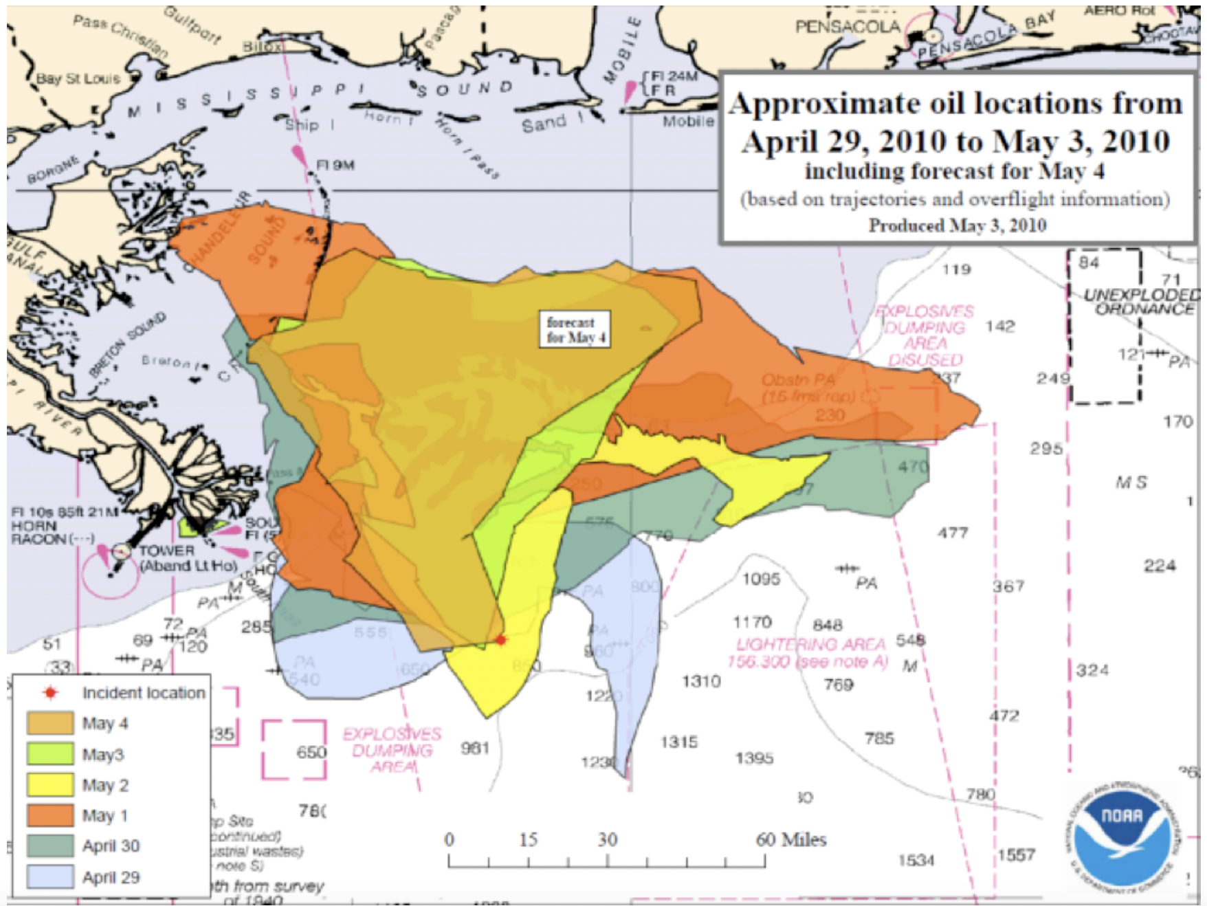
The BP Macondo well blowout is the largest accidental release of oil into marine waters. A total of nearly 5 million barrels of oil from the spill was released into the Gulf waters 50 miles southeast of the Mississippi River Delta in a water depth of about 1,500 m (5,000 feet). The meandering of the oil spill followed the path of the deepwater eddy currents as expected, with relatively small amounts of oil reaching the Louisiana coast, probably by moving up the Mississippi trench (Figure 4).
The second-largest oil spill in the Gulf of Mexico, the exploratory well Ixtoc, blew out on June 3, 1979, in the Bay of Campeche on the continental shelf of Mexico at a shallow depth of 200 feet. It eventually released 10,000 to 30,000 barrels of oil per day for nine months. By the time the well was brought under control in March 1980 by drilling two relief wells to relieve pressure, an estimated 113 million to upward of 300 million gallons of oil had spilled. As forecasted based on shelf currents, the oil traveled 800 miles to the north, oiling more than 150 miles of shoreline in Texas from the Mexican border to Aransas and unknown miles of shoreline in Mexico. It never reached the upper Texas coast because the currents reverse near Aransas.
Other significant oil spills in the Gulf of Mexico involved shipboard accidents or collisions. The oil tanker Burmah Agate collided with the freighter Mimosa on the LATEX shelf southeast of Galveston in November 1979; the tanker Mega Borg had a downloading accident south-southeast of Galveston in June 1990; and the tanker Alvenus grounded in the Calcasieu River Channel near Cameron, Louisiana, in July 1984. In each of these cases, the oil spread along the LATEX coastal shelf by the along-shore current, in line with the predictions discussed below.
Possibility of Future Oil Spills Impacting the LATEX Coast
An oil spill on other coastal shelves (Florida, Yucatan, Campeche) would be very unlikely to reach the north Texas coast. However, a shallow water spill anywhere east of Freeport on the northern LATEX shelf itself would generally be directed downward along the Texas coast and would need to be mitigated. There are some older oil rigs in this area, all of which are susceptible to hurricane damage or an accidental release of oil.
Figure 5
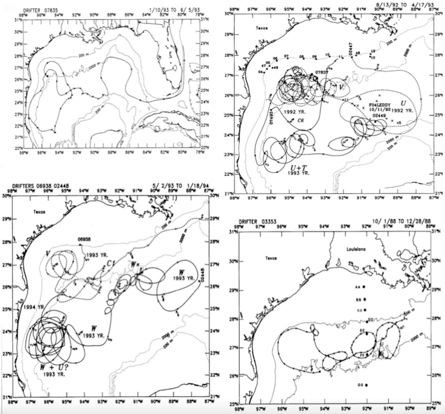
Source U.S. Department of Interior, BOEMRE.
More importantly, though, a deepwater spill anywhere in the Gulf would be very unlikely to impact the north Texas coast. Extensive drift buoy data collected by the National Oceanic and Atmospheric Association suggests that the shelf currents are, in general, dynamically isolated from the deepwater eddy currents by the shelf break (Figure 5). The strong loop current coming into the Gulf through the Yucatan Straight and leaving through the Florida Straight is confined to the eastern Gulf deepwater. Loop eddy currents that spin off and wander erratically in a clockwise gyre through the western Gulf do not appear to cross the deep-shelf slope boundary. This is good news because the latest drilling activities appear to be headed for deeper and deeper Gulf waters.
Figure 6
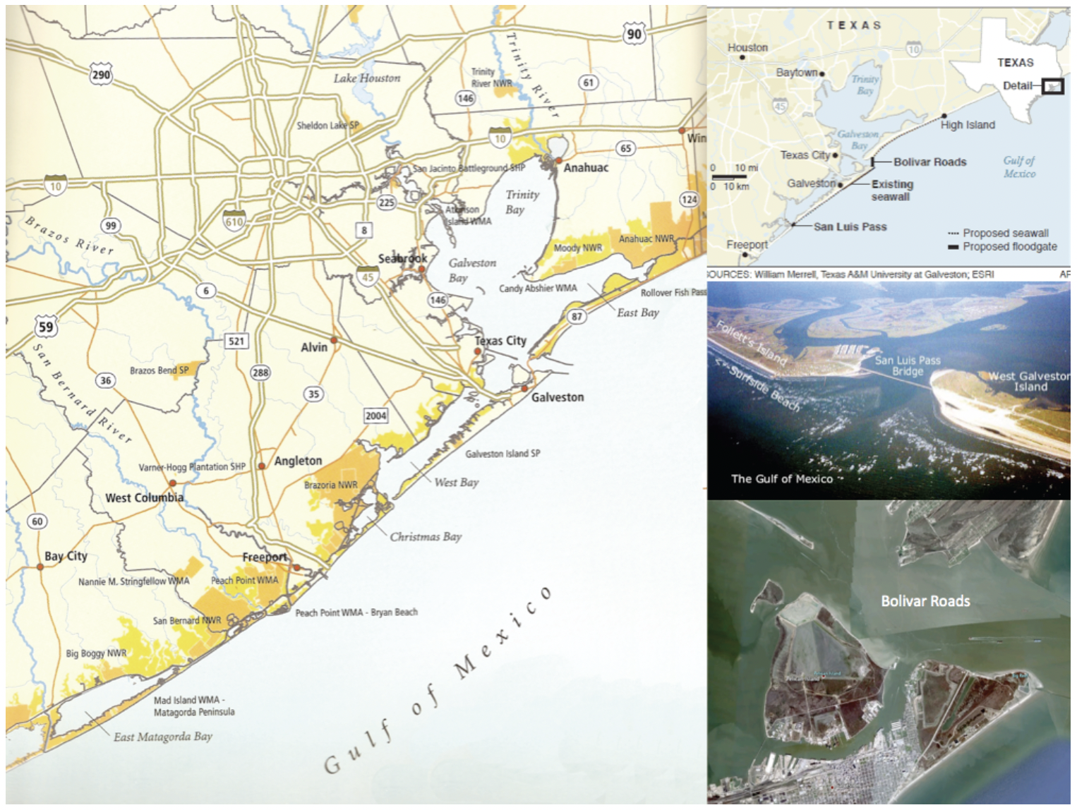
Source Severe Storm Prediction, Education, and Evacuation from Disasters Center, Rice University.
In the event an oil spill occurs in the relatively small area of the Gulf where the currents are likely to carry it onto the LATEX region, a natural line of defense exists to protect the marshlands and estuaries from oil contamination. This line of defense is the barrier island system that stretches from High Island to Freeport, Texas. These sandy-beach islands have only two major breaks: Bolivar Roads and San Luis Pass (Figure 6). The Bolivar Roads channel lies between Galveston Island and Bolivar Peninsula, spanning approximately 3 km (1.9 miles) at its narrowest width. The Houston Ship Channel passes from the Gulf of Mexico to Galveston Bay through the Bolivar Roads. The ship channel itself is only 0.16 km (0.1 miles) wide. Thus, it may be possible to place a permanent barrier across much of the Bolivar Roads with a gated gap centered on the ship channel. This may or may not be ecologically possible, but warrants study in order to come up with the best plan to shut down the opening when necessary. San Luis Pass at the western end of Galveston Island will more than likely require a completely removable barrier to maintain normal exchange of water between the Gulf and West Bay. However, it spans a distance of only 1.2 km (0.75 miles), a distance that is quite manageable. These movable barriers can be stored in a close-by and convenient location to be deployed immediately when needed. The actual design of the barriers should be an improvement over the currently used floatable inflated barriers that are subject to dislocation by wave action and can be breached by surface oil from underneath. This plan does not protect the sandy beaches on the outer shore of the barrier islands, but cleanup there is relatively inexpensive; no plant and little animal mortality is involved, new sand is available, and the marsh system is saved.
References
General Facts About the Gulf of Mexico
Gore, R.H. 1992. The Gulf of Mexico. Sarasota, Florida: Pineapple Press, Inc.
Coastal Shelf Circulation
Berger, T.J., P. Hamilton, J.J. Singer, R.R. Leben, G.H. Born, and C.A. Fox. 1996. “Louisiana/Texas Shelf Physical Oceanography Program: Eddy Circulation Study, Final Synthesis Report. Volume I: Technical Report.” OCS Study MMS 96-0051: 324. New Orleans, LA: U.S. Department of the Interior, Minerals Management Service, Gulf of Mexico OCS Region.
Cho, K., R.O. Reid, and W.D. Nowlin. 1998. “Objectively mapped stream function fields on the Texas-Louisiana shelf based on 32 months of moored current meter data.” Journal of Geophysical Research 10: 103, 377, 390,
Cochrane, J.D. and F.J. Kelly. 1986. “Low-Frequency Circulation on the Texas-Louisiana Continental Shelf.” Journal of Geophysical Research 10: 91, 645, 659.
Dinnel, S.P., J.W. Wiseman, Jr., and L.J. Rouse, Jr. 1997. “Coastal currents in the northern Gulf of Mexico.” OCS Study MMS 9: 113. New Orleans, LA: Department of the Interior, Minerals Management Service, Gulf of Mexico OCS Region.
Oey, L.Y. 1995. “Eddy- and wind-forced shelf circulation.” Journal of Geophysical Research 100: 862-8637.
Reap, M.E., A.E. Jochens, and W.D. Nowlin, Jr., eds. 1996. “Texas-Louisiana Shelf Circulation and Transport Processes Study: Year 3, Annual Report.” OCS Study MMS 96-0030: 82. New Orleans, LA: U.S. Department of the Interior, Minerals Management Service, Gulf of Mexico OCS Region.
Deepwater Circulation
Oey, L.Y., T. Ezer, and H.C. Lee. 2005. “Loop Current, Rings and Related Circulation in the Gulf of Mexico: A Review of Numerical Models and future Challenges.” In: Circulation in the Gulf of Mexico: Observations and Models, edited by W. Sturges and A. Lugo-Fernandez, 31-56. Washington, D.C.: American Geophysical Union.
Sturges, W. and R. Leben. 2000. “Frequency of Ring Separations from the Loop Current in the Gulf of Mexico: A Revised Estimate.” Journal of Physical Oceanography 30:. 1814-1819.
Welsh, S.E. and M. Inoue. 2000. “Loop Current rings and the deep circulation in the Gulf of Mexico.” Journal of Geophysical Research 105: 16951-16959.
Deepwater-coastal Current Interactions
Frolov, S.A., G.G. Sutyrin, G.D. Rowe, and L.M. Rothstein. 2004. “Loop Current Eddy Interaction with the Western Boundary in the Gulf of Mexico.” American Meteorological Society 34: 2223-2237.
Hamilton, P., G.S. Fargion, and D.C. Biggs. 1999. “Loop Current Eddy Paths in the Western Gulf of Mexico.” Journal of Physical Oceanography 20: 1190-1207.
Vidal, M., V. Vudal, F.V. Vidal, and J.M. Perez-Molero. 1992. “Collision of a Loop Current Anticyclonic Ring Against the Continental Shelf Slope of the Western Gulf of Mexico.” Journal of Geophysical Research 97: 2155-2172.
This material may be quoted or reproduced without prior permission, provided appropriate credit is given to the author and Rice University’s Baker Institute for Public Policy. The views expressed herein are those of the individual author(s), and do not necessarily represent the views of Rice University’s Baker Institute for Public Policy.


